2017年11月14日 星期二

Keelung mountain hiking trail in Jiufen


Jiufen (九份) is a very popular place now,  and many foreign visitors go there to enjoy the special style of the old town. Jiufen means 9 things, because there were only 9 family lived in this mountainous area before gold mine was found. If someone went to the town to buy something, he would buy 9 things at the same time.

Keelung mountain is just in front of Jiufen, but many visitors missed the nearby hiking trail. The entrance of the hiking trail is near the parking lot of Jiufen, and is 150 m away from the entrance of Jiufen old street.

Keelung Mt

The trail entrance on the main road.

There are several lookout points on the trail, and you can see the full view of Jiufen and Jingaushi(金瓜石). Because of annual strong wind from the north, the mountains are usually covered with silvergrass, and it wound be very hot on the trail under the sun. Wearing a hat is needed for the sun and wind.

Soon after hiking, two roads will diverge in the silvergrass, and you can choose any one to travel, because the two roads will meet together again.  The main trail (685 m) is steep with thousand of steps, and the branch one (1395 m)  is less steep but longer. It may take you 40 mins to go up and 30 mins to go down. It is rather easy to finish the trail and you can see the gorgeous view of both the mountains and the sea. I recommend you to eat a bowl of sliced ice in Jiufen after hiking, and that wound be a wonderful experience.

The main trail and the branch. 
Steep main trail

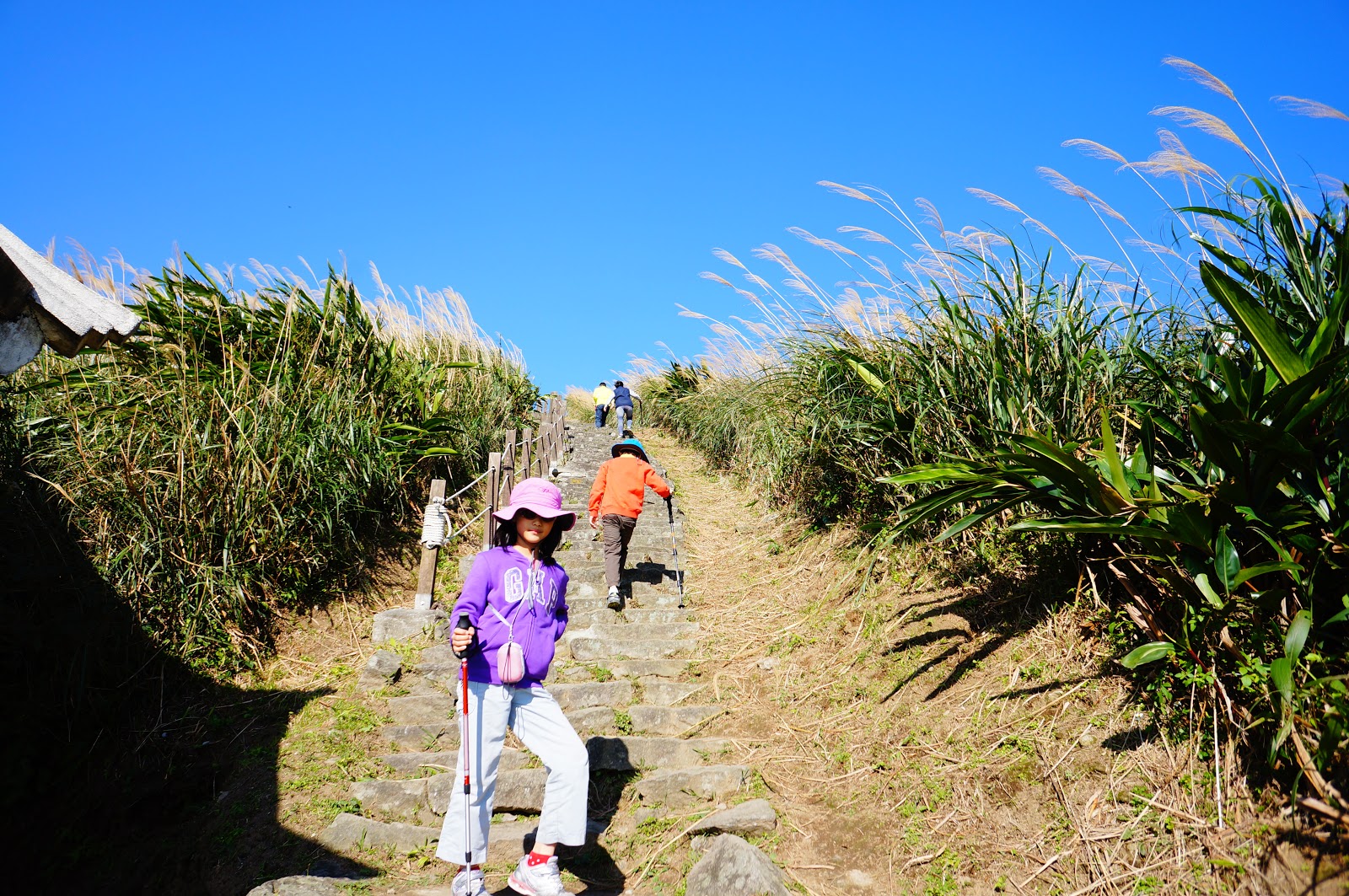
My kids walking on the steep main trail. 

The view on the trail 

The view on the trail

The view of Jinguashi and Jiufen

Beatiful silvergrass

Mountain climbing may change history.  These mountains near Jiufen, including the Keelung island,  were formed about 1 millions years ago by undersea volcanic eruption, therefore some metals, such as gold , silver and copper were brought to the earth surface.

In 1626-1642, the Spanish people built a castle in Keelung, but they were defeated by the Dutch. The Dutch in southern Taiwan were then defeated by Koxinga in 1662. The Dutch occupied Keelung again in 1664, but they leaved Keelung in 1667 because they found nothing good here. Because they did not climb these mountains , they didn't find the gold. The gold mine was found in 1890, and it was once the biggest gold mine in Asia. There is still gold in the deep of Jiufen and Jinguashi.

The whole view of Keelung Mt.  I took this picture on the top of Teapot Mt near Jinguashi. 


Simple info:

Keelung Mt peak (elev 558 m)
Entrance (elev 328 m) , near Jiufen parking lot, 150m away form the entrance of Jiufen old street.
Main trail (658 m)
Branch trail (1395 m)
40 mins go up , 30 mins go down


2017年11月13日 星期一

Qixing Mountain Trails in Taipei

Qixing mountain(七星山) is located in the center of Yangmingshan (陽明山) National Park (YMS NP). It is the highest mountain (elevation 1120m) in Taipei City. Qixing Mt can be also spelled as Chihsing or called as Seven stars Mt. 

The main peak of Qixing Mt.

There are not only skyscrapers and fine food in Taipei. If you have a whole day' time in Taipei, and the weather is good, climbing the mountain wound be a wonderful experience for you.

There are three trails to the Mountain top, which are from the Miaopu(苗圃) , Xiaoyoukeng(小油坑), and Lengshukeng(冷水坑) entrances.


There are parking lots near the 3 entrances. Otherwise, you may take the  Bus 260 from the Jiantan MRT station to the Yangmingshan Terminal Station,  and then take the  Bus 108 which goes around the YMS NP in a clockwise direction, and it will stop at the 3 entrances. The Taipei bus cooperation adjusts the transportation according to the weather conditions. The Bus S15 runs between Lengshukeng and Jiantan MRT station, and it is also a good choice of visiting the mountain.

The Miaopu trail entrance (elevation 570m) is the nearest one from Taipei city, but It is the  toughest one. The Xiaoyoukeng trail (elevation 811 m)  is the easiest one,and you can enjoy the gorgeous volcanic view at the same time.  You can feel the hot air came out from the fumarole ,and smell the unpleasant odor of sulfur compounds from the deep of the Earth. Although the volcano is still active, but don't worry, the last eruption was just 200 thousand years ago.  Menghuan pond  (夢幻湖) which is famous for its underwater plants is near the entrance of Lengshukeng (elevation 750). If you have enough time, you can walk to Qingtiangang (擎天崗) from Lengshukeng (1.7km, 50mins). Qingtiangang is the biggest meadow in northern Taiwan, and the meadow was formed after wildfires.

The entrance of Miaopu trail
The forest part of Miaopu trail

The entrance of Xiaoyoukeng
The fumarole on the Xiaoyoukeng trail
Menghuan pond


The trail in the arrow bamboo. 

It may take 2 hours for the Miaopu trail and 1.5 hours for the Xiaoyoukeng trail (just oneway up). And you can choose anyway up or down. Toilets and drinking water are available at the visitor centers near each trail entrance. There's only one toilet in Qixing park on the trail.

The view of Xiaoyoukeng from the Qixing main peak

The view of the east peak of the Qixing Mt from the main peak


I am on the top of Taipei city.

The top and the northern side of the Qixing Mt is covered with silvergrass (芒草) and arrow bamboo(箭竹), and the special landscape is due to perennial strong wind from the north. Besides it is cooler, autumn is the best season of visiting the mountain because of blooming of silvergrass.

You may see many animals on the trail, such as butterflies and lizards. The chestnut tiger butterflies (青斑蝶) have brilliant wings to warm the predators "poisonous",  and they will not fly away when you close up to them. (They think you are scared, too.) The blue-trailed skink (麗紋石龍子) is famous for its bling-bling tail, and it is a frequently-encountered sunbather on the trail. If you are lucky enough, you may meet a family of bamboo partridges(竹雞). In the forest of Miaopu trail, squirrels and birds are seen commonly, and they also make noises.

The chestnut tiger 

The blue-tailed skink 

The bamboo partridge

On the top of the mountain, you can see the best view of Taipei. There are numerous buildings in the Taipei basin and Taipei101 would be easily recognized among them. Several rivers wind through the basin. You can see the ocean of the northern Taiwan island. The mountain top of Daba (大霸尖山) may be visible, if the weather is so good. A poet said that Taipei basin is like a cello, but I think it's more like a cradle which raises up 6 millions of people at daytime and makes them sleep well at night.

The rivers wind through the Taipei basin.


The weather may change quickly in the high mountain area, therefore be sure to have a raincoat with you.  It is always windy on the mountain top , and do not stay there when thundering. Bringing enough water with you is strongly recommended, since it may be hot under the sun. Luckily, cellular phone is OK at most area of the trails.

Road sings every 200 m on the trail. 


Simple info :

Qixing Mt main peak, elev 1120m.
Miaopu , elev 570 m, 2.5km, 2 hr
Xiaoyoukeng,elev 811m, 1.5 km, 1hr 20min
Lengshukeng,elev 750m, 2km, 1hr 40min

Bus 260 from Jiantan to YMS terminal, then Bus 108  to the 3 entrances.
The bus stop near Miaopu entrance is "Second parking lot/Visitor Center".
Bus 108 Range Car runs between YMS terminal and Erzihping (bidirectional), which pass Second parking lot only. 
Bus S15 runs between Jiantan and Lengshukeng.


2017年11月6日 星期一

奧林匹亞國家公園( Olympic NP)

奧林匹亞國家公園位於美國華盛頓州的西北方 ,與著名的城市西雅圖之間隔著一道海灣。


我們從西雅圖直接開車搭上了渡輪便往對岸的前進,回頭看看整個西雅圖正籠罩在深深的霧霾之中,這陣霧霾因加拿大卑詩省中南部的森林大火而起,一直往南延伸了好幾百公里,看來是註定會影響到我們未來幾天的行程, 雖然空氣之中聞不到一點焦味,但是影響風景的CP值甚高,不得不令人氣結。


我原本以為依地圖看來,只要過了這個海灣就進入國家公園的範圍裡頭了。只是沒有想到要開到公園下一個入口還得多花兩個多小時的時間。這一條沿著奧林匹亞國家公園繞圈的高速公路其實只是雙線道而已。


終於抵達了奧林匹亞國家公園的一座旅客中心, 這裡有相當詳細的國家公園介紹,原來這個國家公園的主題以中央的高山群為主,且並沒有任何穿越其中的公路, 只有環狀線的六個入口可以稍微深入一探究竟。這樣就保留了國家公園中間廣大的生態棲息地。當然囉,這樣的設計會讓旅客玩起來覺得路途不順,但是國家公園確確實實應該就是保護國家公園主體性和生態景觀。

我在這裡看了一個生態電影,其中有一句話讓我非常印象深刻:「倒木是森林的奶媽,她扶養了地衣和蕈類。」 這幾年來我勤走山林,確實發現了一件事情,真正的原始的森林就是到處都是倒木的森林,彷彿死亡和重生不斷輪迴。


參觀完遊客中心之後,我們便完下一個著名的景點Hurricane ridge 前進。

這裡之所以被稱為Olympia 乃是因為這一塊群峰相聚的山頭高聳入雲,似乎為人類所無法企及,於是便以希臘神話眾神的故鄉來命名,原本我們也是應該要看到這神話中的風景,只可惜現在能夠看見的只是迷迷茫茫的一片白霧而已,真傷心。沒關係,我們還是可以在附近的步道隨意走走。


這一個景點叫做 International views 可以居高臨下睥睨加拿大的溫哥華島,當然囉,現在是什麼也看不到,哭哭。雖然如此,在這山徑中漫步,還是讓人覺得舒暢無比,至於那錯過的神之故鄉的景觀,就以後再說吧。


離開了Hurricane ridge之後,我們繼續沿著高速公路以逆時針的方式環繞,下一個我們要停留的景點叫做Forks福克斯,途中我們在一處湖泊旁稍稍停留,親眼目睹了美國人如何在湖邊上下船,感覺真羨慕。


福克斯因為是著名小說及電影暮光之城 Twilight 的故事發生地,所以近幾年來變成了一個有名的觀光景點,這裡其實只是一個2000多人的小城鎮而已。我個人其實沒有看過暮光之城,但是我也很好奇這窮鄉僻壤小地方到底有什麼神奇的魔力?

我們先去這裡的著名海灘 Rialto beach 看看吧! 這個海灘在暮光之城裡被稱為狼人海灘,南方河岸的小村落即為La Push,從福克斯到這個海灘大概還有十公里的距離,途中會穿越一座美麗的溫帶雨林,可能是因為我們來之前下過雨或者是因為這裡天生就比較潮濕,這裡的樹葉看起來都是水水亮亮的,非常的漂亮。 只可惜中間沒有什麼可以停車的地方,所以這神奇的感受只能用粗淺的文字來形容,沒有更具體的照片。

到了 Rialto 沙灘的停車場, 這裡車子停得滿滿的, 一走入沙灘,面前的景色讓人驚嚇,所見皆是許多巨型的漂流木,就像是台灣的紅檜扁柏一樣的巨林恣意傾倒在 Rialto 的沙灘上,這裡是國家公園裡禁止採集,所以才能保有最原始的海岸景觀。我不禁想起如果四百年前,當顏思齊鄭芝龍等探險家登陸台灣的濁水溪時,他們所看到的風景,應該也會像現在我所看到的風景一樣 ,到處都是從高山上沖刷下來的巨型漂流木。


回到了福克斯小鎮上,我們挑了一間中菜館來吃飯。媽呀!真的好難吃啊!這裡的口味都太迎合美國人了,甚至於連糖醋雞肉的糖醋醬都黏得像膠水,而且閃閃發著「粉紅色」的螢光,看起來真可怕,份量也多到吃不完。

接下來我們要去住的是這裡的民宿,check in的時間是晚上6點,check out的時間是隔天的下午2點。這一間房子從外表上看起來很普通,可是當我們已經進到這房子裡頭時,這個美國房子的設備好到讓我們咋舌,有大客廳、有大廚房、有三個大臥室還有兩套衛浴。餐廳的咖啡機前擺了許多明顯是為了籠絡小孩人心的零食,書廚上是整套的Twilight系列,還有十幾套的桌遊,這怎麼能不讓人愛上這座典型的美國民宅呢?


福克斯真的是一個令人靈感滿滿的地方,我在這裡剛好寫完了前一篇小說<赤壁記>的完結篇 , 歸去之後,為了形容眼前所看見的漂流木的風景, 竟然開始寫另一部長篇<海賊王鄭芝龍>, 這是之前從來沒有想到要寫的題材。

隔一天,小孩子們堅持要玩到 check out時間前才肯離開,所以我們在這裡煮了義大利麵午餐。再開車往下一個景點奧林匹亞國家公園的Hoh Rain Forest。


我們一樣沿著高速公路前進,再轉入Hoh valley road 。奧林匹亞國家公園的西側緊鄰太平洋,終年承受來自太平洋的海風及水氣,氣候上屬於溫帶海洋性氣候 ,此地降雨量甚高,所以地面植被呈現溫帶雨林型態。

在Hoh 雨林裡,最著名的是兩條步道,一是 Hall of Mosses Trail (0.85mile),另一是Spruce Nature Trail (1.2mile),雨林是喜溼植物苔蘚類及蕨類的天堂,這裡最奇特的景觀則是樹上都掛滿了苔蘚類的松蘿。步道中的樹身上面都掛著滿滿的松羅,還好天光甚明,遊人甚多,加上我心無罣礙,故無有恐怖,遠離一切顛倒夢想,不然眼前的景像如果在暗夜無光的時候必定覺得十分可怖,直接就會聯想到倩女幽魂裡的樹妖姥姥。


這幅是池水,秋季來時,裡頭會有鮭魚
回程繼續開車,我們打算南迴繞奧林匹亞半島一圈,並且投宿在奧林匹亞市,這一路開車非常非常的無聊,大概開了四個小時以後才到達奧林匹亞。中間在一個叫做Aberdeen的小城遇到了塞車,塞車時候竟然看見了一幅大牆壁上寫著  "我們感謝以下的國家在19世紀的時候,協助我們創立Aberdeen",其中竟然有我們的前前任國旗:


大清帝國國旗,這在台灣都很難見到了。

奧林匹亞國家公園確實是一個以生態至上的國家公園,雖然它的名氣遠比附近的雷尼爾山國家公園小的多,但是其實內容更豐富。這也讓我想起了以前在荒野上課時說到的一句源於此地的名言: 

"Treat the earth well: it was not given to you by your parents, it was loaned to you by your children. We do not inherit the Earth from our Ancestors, we borrow it from our Children."

Ancient Indian Proverb